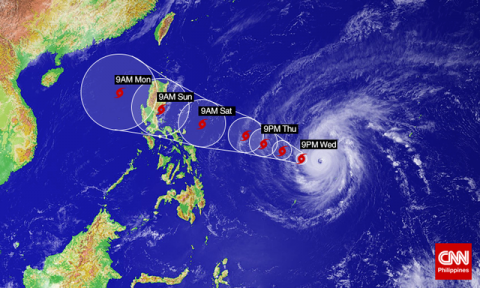
This update comes to those in northern Philippines – as of Midnight April 2, on the path, direction and speed of Typhoon Chedeng.
The typhoon has a rainfall radius at this time of 150-200km with heavy and often intense downpours.
Within 18 hours and Philippines will raise Public Storm Warning Signal #1 over Bicol and Samar Provinces. Once the signal is raised, sea travel will be suspended.
Typhoon Chedeng is estimated to make landfall on the eastern coast of Aurora, Quezon or Isabela regions by later Saturday to early morning Sunday.
The public is being alerted against possible flash-floods over low-lying areas and landslides along mountainous slopes, particularly in Aurora-Quezon area.
Storm surge and sea waves of up to 4 meters are possible over the entire area of Eastern Samar, Bicol and Aurora-Quezon.
Fishermen are strongly advised not to venture out over the eastern seaboard of Bicol Region and the Visayas.
At 11;00 p.m. April 1st, the eye of Typhoon Chedeng was located 1,015 kilometers East Northeast of Guiuan, Eastern Samar or 1,040 kilometers East of Borongan, Eastern Samar.
The typhoon is sustaining winds of 180 kph near the center and gusts of 215 kph – it is forecast to move West Northerwest at 19 kph.
Forecast Positions:
• 24 hour (Tomorrow evening): 850 km East of Legazpi City, Albay
• 48 hour (Friday evening): 620 km East of Infanta, Quezon
• 72 hour (Saturday evening): 130 km East Southeast of Casiguran, Aurora
