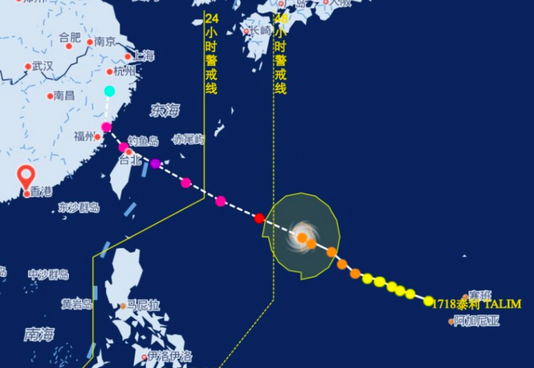
Up to half a million people in southeast China will be evacuated as the region braces for typhoon Talim, which is expected to make landfall this week.
Although Typhoon Talim formed to the east of the Philippines, it is expected to spare the country.
Liu Aiming, the chief engineer at Fujian province’s meteorological bureau, said the typhoon was expected to strike several coastal cities including Fuzhou and Ningde.
The typhoon was first spotted to the east of the Philippines on Saturday. It has been steadily gathering strength and is expected to be a super typhoon by the time it hits land. This is the highest level in China’s typhoon rating system.
Ms Aiming said: “Talim is a giant. It will dwarf any of the others we’ve seen this year.”
Last month, the south of China was hit by Typhoon Hato, which caused flooding and destruction across a wide area.
Bracing for typhoon Talim
She also said that people would be forced to leave their homes by inspection teams made up of Communist Party and government officials.
“It’s routine practice. If they were not told to evacuate most people would just stay in their homes. Nobody hits the highway.”
Huang Peng, a professor in architecture and wind engineering at Tongji University in Shanghai, said: “In China, mass evacuations are usually not considered an option, but for those living in poorly built properties or at-risk locations it is better if they are relocated.”
According to Wang Kanghong of the Ministry of Education’s meteorological disaster laboratory, the government was selective about ordering evacuations. Orders were issued only if the data suggested a building was vulnerable to a typhoon.
“However the climate is changing. It is possible we will one day be faced with a mega-typhoon that few buildings would be able to withstand,” he said.
“There has never been a drill. Many things can go wrong.”
Tropical Depression Maring
Meanwhile, more areas were placed under signal number 1 as Tropical Depression Maring maintained its strength and continued moving west northwest today (Monday, September 11).
State weather bureau PAGASA said Maring was already 255 kilometers east of Infanta, Quezon, moving at 13kph.
The tropical depression continues to have maximum winds of 45 kph and gustiness of up to 60 kph.
Signal number 1 is raised in the following areas due to Maring:
- Metro Manila
- Catanduanes
- Camarines Norte
- Camarines Sur
- northern Quezon including Polillo Island
- Rizal
- Bulacan
- Pampanga
- Quirino
- Nueva Ecija
- Tarlac
- Aurora
Maring is bringing moderate to heavy rain to the regions of Bicol, Calabarzon, Mimaropa, Metro Manila, and Central Luzon, as well as the province of Pangasinan. These areas should watch out for floods and landslides.
The tropical depression is expected to make landfall in the Quezon-Aurora area tomorrow afternoon.

Comments are closed.